An Explorer's Guide to the Alaska Highway
Dateline: December 25, 2023.
This 34-page brochure was published by the Canadian Department of Northern Affairs and National Resources. We have posted the primary information from it below, exactly as it was written (approximately 5 pages in total), but you can see the entire brochure here. For ease of use, the six-page Accommodation and Roadside Facilities section is on a separate page.
 INTRODUCTION
TO A YUKON ADVENTURE
The modern automobile traveler with a taste for adventure has a wonderful journey awaiting him along the Alaska Highway.
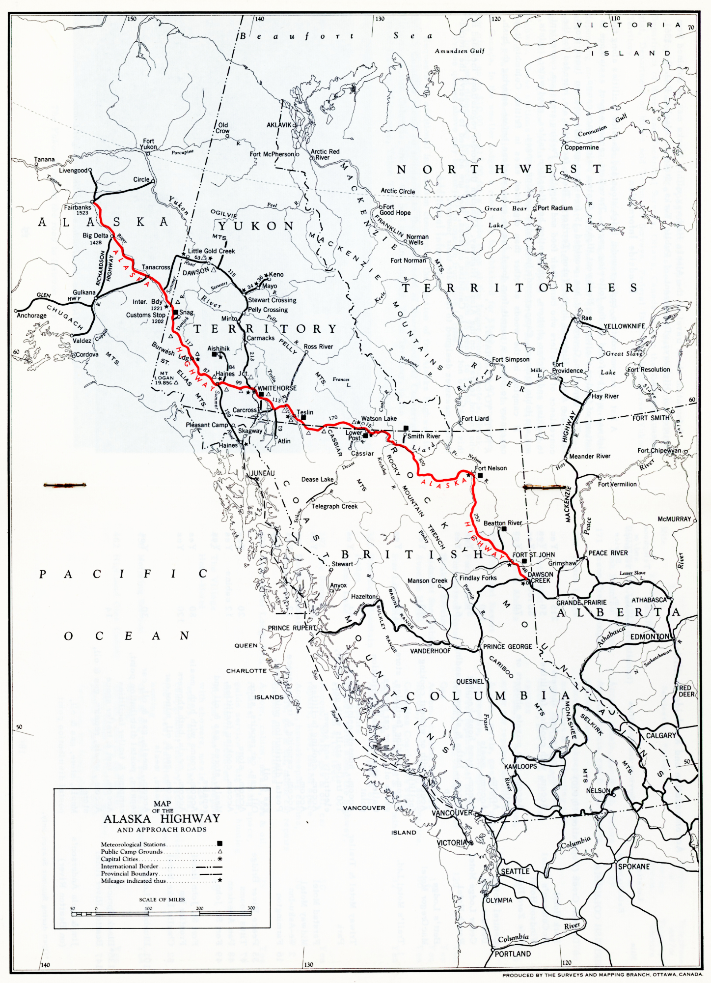
The 1,523-mile highway winds its scenic way from Mile "0" at Dawson Creek, British Columbia, through Canada's storied Yukon to Fairbanks, Alaska and it ranks high on the list of world renowned vacation routes. It passes through an exciting, rugged
frontier land, rich in natural beauty and remote from civilization. All but 300 miles of the road lies in Canada.
This unique trip will take you through a land of mystery and enchantment. You will see a densely forested Rocky Mountain region, and drive past silent, tree-lined lakes, along spruce and birch-clad river valleys offering scenes of breath-taking beauty. The whole region cut by the highway is a sportsman's paradise.
Fishermen find superb sport in the swift running streams and in the clear, icy northern lakes. You may stop along the way and try your luck with the elusive Arctic grayling, giant lake trout and rainbow trout; and in season the hunter will find moose, Dall sheep, bear and other big game in abundance,
Careful planning is the key to a successful and carefree vacation along the Alaska Highway. Schedule your trip for the period from June to October. At other times of the year you may experience extreme winter cold and during spring thaws driving is sometimes uncomfortable and difficult for a pleasure trip. The road, however, is open all year long and it is the finest all-weather gravel highway in Canada. As the Alaska Highway is not a paved road, dust conditions are bound to be encountered in dry weather. The road
alignment, grades and sight distances are good and it is possible to average an ordinary
day's driving on the Highway. You can also plan on having up to 20 hours of daylight in
this part of the country during the summer period.
Mosquitos and black flies may be encountered in some areas but if you carry a supply of some of the modern repellents they won't mar your trip in any way. It's best to remember, too, that nights in the northern mountain regions can be quite cool, even in mid-summer, so if you're planning on camping along the Highway come prepared with a set of blankets and some warm clothing.
Accommodation, stores, meals, gas, oil and repairs are available at convenient stops along the entire route, and if you like to camp out there's plenty of opportunity, including 15 prepared camp-grounds with cooking and other facilities in the Yukon section.
Let's take a look at some of the exciting things to see along the Highway. At Fort Nelson, the road winds through the most northerly extension of the Rocky Mountain range, climbing to the highest point on the route at Summit Lake, Mile 392, where the elevation is 4,156 feet.
Hot springs bubble outof the ground inthe vicinity of Toad River Gorge and the Liard River, nearly 500 miles north of Dawson Creek. Hence the Indian Legend of "Paradise Valley", enshrouded in mystery and abundant with tropical flowers and vegetation.
If you're a camera enthusiast, take plenty of colour film, for the scenic splendor of the Alaska Highway is perhaps unsurpassed anywhere in the world. Views of exceptional beauty may be seen at Muncho Lake in the Canadian Rockies, Teslin Lake, Mile 804, which bears the Indian word for "long" and winds for many miles along the Highway. At
Mile 1064 you will see the inspiring mountain scenery around Kluane Lake, largest in the
Yukon, and just 20 miles from Haines Junction the Kathleen Lakes provide the setting for one of the most beautiful scenes in the Canadian Northwest.
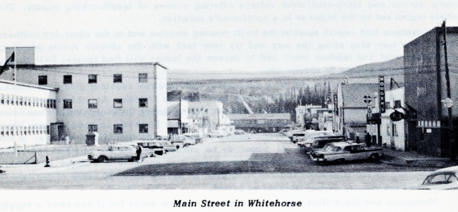
Whitehorse, Capital of the Yukon, and centre for communications and mining, combines the conveniences of a modern city with all the colour and excitement of a bustling frontier community. Visitors can see the unique Indian burial ground north of the city. Some of the graves are covered by small houses, in which dishes, tobacco, pipes and other items are often placed in the belief that the spirits might return.
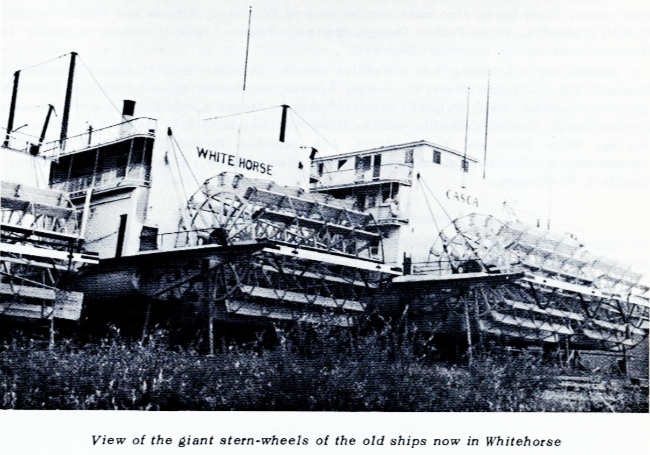
In Whitehorse old sternwheeler steamships are sitting on wooden piles in a group along the river bank, These are the last survivors of the Gold Rush Flotilla and the once heavy water-borne commerce on the Yukon River from Whitehorse downstream to Dawson and beyond. Visitors, too, can see the MacBride Museum in the city which houses an
outstanding display of items collected from the Gold Rush period.
Just six miles south of Whitehorse a road leads from the Alaska Highway to Miles Canyon, a fantastic slash in the earth, where the clear green waters of the Yukon River swirl past multi-coloured cliffs of volcanic rock which rise to heights of 125 feet or more. A suspension bridge across the Canyon gives visitors a chance to view the rushing
waters at close range.
On the east side of the Canyon you can walk a scenic trail winding along the cliffs and follow the route of one of the most unusual tramways ever built. It was constructed in 1898 to transport supplies and equipment past the dangerous Canyon and Whitehorse Rapids, and was made entirely of wood. Wagonloads of miners' goods were transported by freight wagons which ran on wooden rails and were drawn by horses. Headquarters for this strange railway was Canyon City, built on a gentle backwater in the river just one mile above the Canyon, and the wooden rails were laid from Canyon City to Whitehorse - a distance of five miles. Traces of the rails can still be seen, and though little remains of Canyon City, you can still see the outlines of the buildings and the rock piers of an extensive dock are still in place.
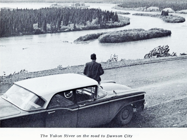
An alternate route from Whitehorse to the State of Alaska passes through Dawson City and is always a rewarding experience. The famed centre of the Klondike Gold Rush, it has many reminders of this earlier time. You'll see the Nugget Dance Hall, and the old Northwest Mounted Police Barracks. You can visit the placer workings in the Klondike River Valley, or climb the mountain known as "Midnight Dome" for a spectacular
Panoramic view of the region. The section of this highway from Whitehorse to Mayo and
Dawson City is open year 'round but the stretch from Dawson City to Tok Junction, Alaska, is open during the summer months only.
In Dawson and Whitehorse visitors shop for such delightful handicraft items as delicate ivory carvings, jewelry fabricated from raw gold panned in nearby creeks, or unusual pieces of Indian beadwork.
The Alaska Highway has all the ingredients required for a memorable vacation - it's a journey that will take you to the top of the world.
Alaska Highway - Canadian Section
Construction of the Alaska Highway, once known as the Alcan Highway, began in March 1942 as a military route and was completed in 1943. Its total length from Dawson Creek, British Columbia to Fairbanks, Alaska, is 1,523 miles, of which 1,221 miles are in Canada and 302 miles in Alaska. It is paved from Dawson Creek to Charlie Lake at
approximately Mile 52. The remainder of the highway has a gravelled, all-weather surface
from Dawson Creek through British Columbia and the Yukon Territory to the Yukon-Alaska Boundary. It ranks as one of the finest gravelled highways anywhere, and is open to travel throughout the year. It is operated and maintained by the Canadian Army (Northwest Highway System), with Headquarters at Whitehorse, Yukon Territory.
The Alaska Highway through Canada commences at Dawson Creek, British Columbia (Mile 0.0) and enters Alaska at Mile 1221. Dawson Creek is the terminus of a Branch of the Northern Alberta Railways (495 miles from Edmonton) and the Pacific Great Eastern Railway from North Vancouver (720 miles), Pacific Great Eastern's Northern Terminus is Fort St. John (at Milepost 49 Alaska Highway),
Motorists from the Pacific and Western States can drive through British Columbia over Highways 1 and 2(97) and the John Hart Highway to Dawson Creek, a distance of approximately 748 miles from Vancouver. From Osoyoos, at the Washington State border,
the distance is 761 miles.
The paved route from Coutts, Alberta, over Highways 4, 2, 16 and 43 to Dawson Creek which is 761 miles is the better approach for motorists from the Pacific and
Midwest States.
Paved highways through the Prairie Provinces offer more direct connections to motorists from the East and Central parts of the North American Continent.
Border Crossing Information
Crossing the U.S.-Canadian border either way is made without difficulty or delay by permanent residents of the U.S.A. They do not require passports. To assist officers of both nations to speed the crossing, however, native-born U.S. citizens should carry identifying papers such as birth, baptismal or voter's certificate, driver's licence, or special letters. Other residents from the United States are advised to have either a Naturalization Certificate or an Alien Registration Receipt Card.
Entry of Vehicles
Conditions for driving along the Alaska Highway have improved to such an extent in recent years that cash or guarantee bond for export is no longer required to cover admission of personally owned automobiles or house-trailer units. (Commercial vehicles must still be bonded.)
Automobiles and trailers will now be admitted without payment of any duty or fee under the usual Travellers' Vehicle Permits readily obtainable at border crossing points. These permits are good for any period up to six months, You should be sure to carry your Vehicle Registration Card.
No difficulty need be expected when towing house-trailers up to fifteen feet long over the Alaska Highway. It is suggested, however, that house-trailers from sixteen feet to thirty feet in length be pulled by an automobile not lighter than the Ford-Plymouth-Chevrolet class. If your trailer is more than thirty feet in length, it is recommended that your vehicle be equivalent in rating to at least a three-quarter ton truck, thus ensuring that it is equal to the task.
If your motor vehicle-trailer combination is more than sixty feet long, eight feet wide or fourteen feet high, you must get a permit to travel over the Alaska Highway from Headquarters, Northwest Highway System, Whitehorse, Yukon Territory, or from the Garrison Commander, Dawson Creek, British Columbia.
Persons entering Canada with the intention of driving over the Alaska Highway must still satisfy the examining officer at the Canadian Border that they have sufficient funds in cash, travellers' cheques, etc. to finance the trip. To help you decide the amount needed, estimate the overall driving distance and the length of time involved, expenses for gas and oil, food and lodging, and allow a reasonable sum for possible repairs.
BAGGAGE, FURNITURE AND EQUIPMENT
You may bring into Canada, free of duty or deposit, personal belongings, sporting equipment, radios, musical instruments, still and moving picture cameras, six rolls of film and twelve flash bulbs per person, typewriters for personal use, 50 cigars, 200 cigarettes, two pounds of tobacco, 40 ounces of alcoholic beverage, two days' food
supply per person and gasoline for 300 miles motoring.
FIREARMS - FISHING TACKLE
A visitor does not require a Federal permit to possess rifles, shotguns or fishing tackle in Canada. He must provide Customs with a description of such equipment and serial numbers of guns so that the articles may be readily cleared upon leaving Canada.
Such permission does not give the right to hunt or fish, There are specific laws in all provinces which must be observed. Non-resident licences are required for each province where the visitor plans to hunt or fish. When rifles and shotguns are carried in transit, the visitor should ensure that he is familiar with the laws of the provinces through which he is travelling.
In British Columbia, non-residents may have firearms or fishing tackle in their possession while in transit either by private car or public conveyance without need of a licence or seal. In Alberta, rifles and shotguns carried in transit must remain stowed in the car at all times. Fifty (50) rounds of ammunition per person are admitted duty free.
NOTE
Revolvers, pistols, or other prohibited weapons, the personal property of persons travelling by highway to and from Alaska through Canada, may be allowed entry without special firearm import permit, under the following regulations:
(1) Such firearms must be placed in a separate container and sealed by Canadian Customs.
At the port of exit the seal will be removed by the Customs officer. If there is indication that it has been tampered with, the firearm will be seized.
Provincial Approach Roads
Alberta's main highways from the United States border and from the boundaries of Saskatchewan and British Columbia are paved. There are two direct approaches from Edmonton to Dawson Creek, The shorter route via Highways 16, 43, 34, and 2 is paved.
The other approach (Highway 2) is paved to Westlock about fifty miles north of Edmonton,
The two principal approach roads through British Columbia from Vancouver and Osoyoos are paved to Summit Lake (28 miles north of Prince George); from that point there is a well maintained gravel-surfaced highway to Dawson Creek. These highways are in
good condition in all seasons except when unusual weather prevails.
Current road reports for Alberta and British Columbia may be obtained from the Director, Alberta Government Travel Bureau, Legislative Building, Edmonton, Alberta and from the British Columbia Travel Bureau, Victoria, BC. respectively.
Cars with Tubeless Tires
Because of the lack of proper equipment at small establishments, parties travelling over the Alaska Highway with tubeless tires are advised to carry spare inner tubes as a precaution. Should wheel rims become damaged the inner tube can then be placed in the tire, making it possible to continue the journey.
Road Conditions
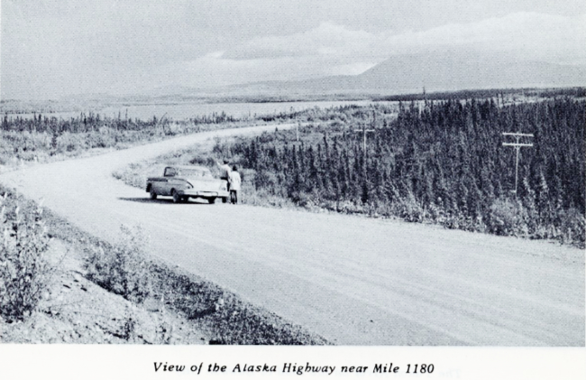
Approach roads through the Provinces of Alberta and British Columbia as well as the Alaska Highway are being improved every year and most hazards of the journey have been eliminated. However, it is still a long journey.
Weather has a great influence on travelling conditions along the Alaska Highway. The following summary will give a general idea of seasonal conditions:
DECEMBER - JANUARY - FEBRUARY
During these months snowfall usually averages from 10 to 15 inches a month, and the highway is generally in good condition, Hard-packed snow provides smooth driving, Below-zero weather prevails at this time of the year. Precautions should be taken to have necessary clothing for protection against such weather. Automobiles should be completely winterized to withstand 60°F. below-zero temperatures. Tire chains, tow-rope, shovel and means to produce fire should be brought along.
MARCH - APRIL - MAY
Melting snow creates icy conditions during March. Throughout the months of April and May the highway is usually poor owing to spring thaws. During this period highway maintenance authorities may find it necessary to restrict travel in certain sections. This may involve short delays until repair work can be completed by maintenance crews. In such cases warning signs are prominently displayed. The motorist is advised to drive with extra caution during these months and to carry tire chains, tow-rope and shovel.
JUNE - JULY - AUGUST - SEPTEMBER
These months are the most favourable for motoring. The days are warm with cool evenings. The road is well graded, although a long dry spell tends to make it dusty. It is suggested that a motorist travelling at this time carry a good spare tire, insect repellent and a basic set of car tools. It is also advisable that the underpart of the gasoline tank be protected with a piece of rubber tire or inner tube against flying gravel.
When heavy dust conditions are encountered, headlights should be used for better visibility, and tail lights should be kept dirt free.
OCTOBER - NOVEMBER
During October and November rain, light snow, and frost cause slipperiness. Travellers should acquaint themselves with highway conditions. This information is usually posted at telephone repeater stations or highway maintenance camps en route. Chains, a container of sand, and a shovel should be carried.
HAINES HIGHWAY
The Haines Road, connecting the port of Haines, Alaska, with the Alaska Highway at a point approximately 99 miles west of Whitehorse, Yukon Territory, is open to traffic during the summer period from June to October inclusive.
WHITEHORSE - MAYO - DAWSON HIGHWAY
The section of highway from Whitehorse to Mayo and Dawson is a good gravel road open to traffic year 'round but the stretch from Dawson City to Tok Junction, Alaska, is open during the summer season only,
CANOL ROAD
The 146 miles of Canol Road, from the Alaska Highway to Ross River, was rebuilt and is suitable for automobile travel. There are no facilities whatsoever between the Alaska Highway and Ross River and only limited facilities at Ross River, ie. a small
store, some accommodation, There are no service stations along the route or at Ross
River and anyone making the trip should carry sufficient gasoline and oil for the round
trip. It would be a scenic and interesting journey but facilities are just not available.
Telephone and Telegraph Services
The Northwest Communication System, operated by Canadian National Telegraphs, provides facilities for public long distance telephone and commercial telegraph services.
Connections may be made with agencies for exchange of telegraph and telephone messages with Alaska; telegraph messages with sections of Northwest Canada; and with Edmonton for telephone and telegraph messages to or from any destination,
The Northwest Communication System also has interchange arrangements with
Department of Transport facilities at Fort St. John, Beatton River, Fort Nelson, Smith
River, Watson Lake, Teslin, Whitehorse, Aishihik and Snag.
Bus Services
Canadian Coachways operate bus services from Edmonton, Alberta to Dawson Creek, British Columbia and over the Alaska Highway to the Yukon-Alaska Border at Beaver
Creek where connections are made with Alaska Motor Coaches for Fairbanks, Alaska. This company also provides a regular service from Whitehorse to Dawson City.
The White Pass & Yukon Route operate buses during the summer months from
Whitehorse, Yukon to Beaver Creek, Yukon where connections are made with Alaska Highway Tours for Fairbanks, Alaska.
Greyhound Lines of Canada Limited service cities and towns from Winnipeg to the west coast. Their buses also make regular runs to Edmonton, Alberta and Prince George, British Columbia. From Prince George, Northern Stages Limited operate regularly to
Dawson Creek via the John Hart Highway.
Gasoline, Meals, Accommodation
The price of gasoline along the Alaska Highway ranges from 42 to 68 cents per gallon depending on the distance and cost of haulage from main distribution centres in Canada and Alaska. Motorists are reminded that gasoline stations in Canada use the Imperial measure, which is one-fifth greater than the United States measure; hence five Canadian gallons are equal to six U.S. gallons.
American gasoline credit cards are readily accepted at affiliated stations along the highway. These stations are serviced by Standard Oil, Chevron, Imperial-Esso, B.A. and Texaco.
Prices of accommodation and food compare with those in the U.S. and main sections of Canada. In the smaller lodges a room may be obtained for $3.50 and $4.00 per person per night, up to $10.00 or $12.00 for a double room at the larger inns and hotels. Breakfast, lunch and dinner may be purchased at prices ranging from 75 cents to $3.00.
Prices quoted above may be subject to change from time to time.
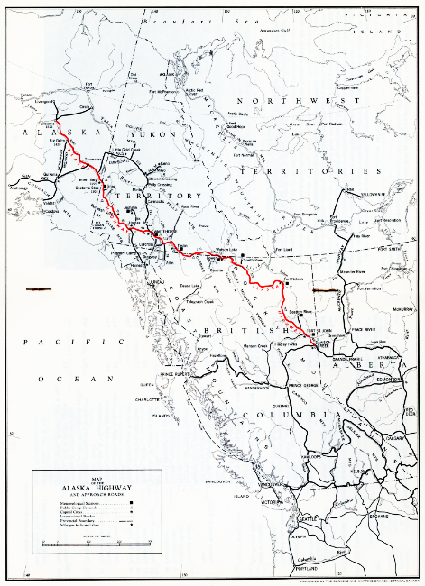
Click on the map to greatly enlarge it in a new window.