Hiking through history on Montana Mountain, Yukon, 1991-1995
This is one of a series of hike reports written from 1991 to 1995 as I was researching the historic mines on Montana Mountain, Yukon, for my first book, "Fractured Veins & Broken Dreams." I carried a notebook, a tape recorder, and a camera on most of the hikes. Photos from each of the hikes have been added.
Dateline: December 30, 2023.
The text of the printed report is in italics.
Km 0 - Carcross end of the bridge on the South Klondike Highway.
Km 0.4 - Turn right on first road past bridge (unmarked).
Km 0.9 - Turn left at "T"
Km 1.3 - Straight through at crossroads.
Sign just past crossroads: "Road is maintained by and
for Feather Gold Resources Ltd. Use at your own risk ..."
Road gets very rough; some may consider it too rough for
a car. Climbs steeply to Km 3.8
Km 4.8 - Mine on right - keep left
Km 0.5 - Slide: road washes out regularly. Approximate treeline. Road very rough again for 1/2 Km past slide area.
Km 11 - Trail to Buddhist temple
Km 11.4 - Hairpin turn to left: view up length of Watson River Valley to Whitehorse.
Km 13.6 - Top: Big Thing Valley (50 min. from Carcross with stops)
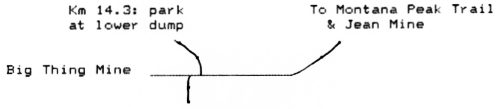
Km 14.3 - Start hiking
20 min. - Big Thing Creek: wade (min. 1 foot deep)
38 min. - Small creek (drinkable): excellent view over Tagish Lk.
55 min. - Alaska Harebell, Ross avens (possibly Snow buttercup)
common in pass; healthy field of cotton grass at bottom of snowfield to right.
1 hr 25 - N. Fork Montana Creek (dry; flowing deep under rocks). Remains of a small sled-bunkhouse, heater, toilet with no walls.
1 hr 45 - Montana Creek & Mountain Hero Mine; stone village, at least 8 tramway supports (most fallen).
2 hr 10 - Montana Mine
2 hr 40 - Pooley Creek and Aurora and Thistle Mine; stone village, stone base of huge outhouse. Mine is up trail to west.
25 minute trail to north of stone village goes past large lake, dead-ends in tight valley; same cat trenching.







