Hiking through history on Montana Mountain, Yukon, 1991-1995
This is one of a series of hike reports written from 1991 to 1995 as I was researching the historic mines on Montana Mountain, Yukon, for my first book, "Fractured Veins & Broken Dreams." I carried a notebook, a tape recorder, and a camera on most of the hikes. Photos from each of the hikes have been added.
Dateline: December 31, 2023.
The text of the printed report is in italics.
Weather is forecast as variable cloud, high of 21, with 30-40km winds. This trip is meant to finish off my photo-inventory. It will be mainly a driving trip, with some hiking, both out of necessity and desire.
08:00: leaving the highway at Carcross - altimeter set at 560m, odometer at 0. Scattered clouds, 7 degrees. The lower road has been freshly graded ('Catted) to make the washouts passable for a car. Very strange. Photos #1 and 2 are of the road work at 1.1km,
635m.
Photo of what I believe to be the Grizzly Bear Mother cirque.
Did I get lucky - up at treeline, I stopped to admire the view, and turned the truck off. I heard a little "ssss" from the truck, and saw that a tire was going down; a little late, it occurred to me that I had no tools, and the stock wrench won't take the front
carrier bolts off. So I tore like a madman down to the Carcross store, borrowed a crescent wrench, and fixed it there.
08:50: leaving the highway again.
09:50: the road to the Buddhist hut is at 10.5km from the highway. It's pretty well grown over, but was wood-cribbed for the first 20m or so. Several photos of hut, deck out back, prayer flag posts, cribbing, etc.
11.9km: the road to W.L. Phelps' Big Thing camp. 1435m.
The first marmot I've seen on the mtn. was sunning himself just above the original Big Thing camp on Big Thing creek.
13.7km: Lower Arctic Caribou adit.
15.1km: Big Thing Creek crossing.
17.2km: Narrow pass - excellent wildflower area (best on the mountain. Photo with peaks in the background. 1530m.
Photo of tarn and old sled camp taken from 18.5km. The camp is at 19.0km. Photos of sled-shack, potty and furnace.
Mountain Hero tramway: from the adit, there is the collapsed terminus bldg, then one stand still up, then 6 stands collapsed, then the large stand that held up the west end of the valley crossing, then the 3 collapsed ones over the summit.
The light is good for the photos to show the trail network that connected all of the tramway stands and the Leynor compresser. Stopped by 4 feet of snow at 20.2km, just before the creek crossing at the Mtn. Hero.
Above the Mtn. Hero stone house is the vague remains of a tent camp. On the top level are possibly 3 tent areas; to the west, about 3m lower is another; just to the east is the collapsed remains of a wooden bldg about 3m wide x 7-8m long.
Above this camp are what appears to be 2 collapsed adits, the first about 25m above it, the next another 6m higher. There is what apears to be a trail to the lower one. What pointed the way to these was a few pieces of lumber scattered down the slope.
Heading back; photo of old campfire remains is just NW of the narrow pass, at 1490m., 16.7km.
The probable hunting blind is directly across from the first adit above the stone "telephone office" at the Big Thing (there are 3 collapsed adits above the Big Thing, as well as a pit with some interesting minerals around it).
Last photo is of the Jean. At the southeast part of the Jean camp was a fallen claim post, "Post No.1, Claim 74839".

A Buddhist ashram on Montana Mountain.

Mine camp, originally staked as the Big Thing by Willard Phelps in 1906, later operated as the Peerless.
Located at 1435m elevation, 11.9 km from Carcross.

Aerial tramway tower, collapsed tramway terrminus, and Mountain Hero adit.
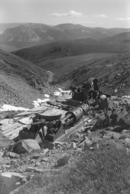
Leynor 12x14 Compound Air Compressor installed in August 1905 on Conrad Creek
below the Mountain Hero Mine.







