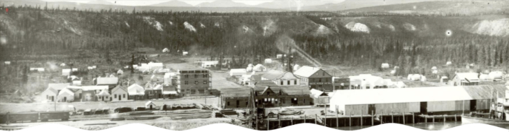
Whitehorse is located within the Chu Nìikwän/Yukon River valley on the traditional territories of the Kwanlin Dün First Nation and Ta'an Kwäch'än Council. These first people refer to this section of the river as Chu Nìikwän, which translates to "water, face, moonlight," and describes the beauty of the river. The Chu Nìikwän/Yukon River valley is framed by mountains, with Thè Mbay (Grey Mountain) to the east, Thay T'aw (Haeckel Hill) to the northwest, and T'si Ma (Golden Horn Mountain) to the south. The Ta'an Kwäch'än are concentrated along southern Ta'an Män/Lake Laberge, as far north as Braeburn, Hootalinqua and Takhini areas. The Kwanlin Dün are concentrated in the Whitehorse area, around Kwanlin//Miles Canyon, Lu Zil Män/Fish Lake and Takwädadha/Marsh Lake, and as far north as Braeburn and Takhini.
Southern Tutchone oral history, archaeological and geological research all indicate that shortly after the Chu Nìikwän/Yukon River valley became deglaciated, around 10,000 years ago, it was inhabited by first peoples, the ancestors of Ta'an Kwäch'än Council and the Kwanlin Dün First Nation.
Local Southern Tutchone oral history that has been passed down for generations describes the time when glacial lakes covered the Chu Nìikwän/Yukon River valley and transformed into the land we know as Whitehorse today. Archeological evidence at Dadal Män/Annie Lake, Lu Zil Män/Fish Lake, and Ta'an Män/Lake Laberge confirms continual use of hunting and fishing camps beginning 8,000 to 5,000 years ago but archaeologists suggest some of these areas were inhabited shortly after deglaciation. Geological information tells us around 12,000 years ago glacial lakes receded very rapidly as an ancient ice dam at the end of Glacial Lake Laberge broke, draining the land that would one day become the city of Whitehorse. New plant and animal species emerged as the area transformed into an inhabitable river valley. Fish became a reliable food source and salmon drew people to the river to fish, gather and visit. Over the long and prosperous chapters of history that
followed, generations of Tlingit, Kaska, Han, Gwich'in, Northern Tutchone, and other First Nations came to trade, feast, fish and gather with the Tagish Ch'än and Southern Tutchone in the area. These relationships have persisted through time and Kwanlin Dün and Ta'an Kwäch'än continue to have cultural affiliations with all the surrounding First Nations, as well as with the Inland and Coastal Tlingit.
The most recent chapter of history in the Whitehorse area includes the influx of traders, miners, army personnel and settlers, and marks a time of significant socio-cultural and economic change that has had a lasting impact. During this chapter, the land was once again transformed. The Chu Nìikwän/Yukon River, and most of the geographical features along it, are renamed by Hudson Bay traders and Frederick Schwatka who mapped and renamed land features and waterways as he travelled the river with the help of his Tlingit guides in 1883. The placename "White Horse", coined by prospectors and settlers moving into the area to participate in the infamous Klondike Gold Rush of 1898, is made permanent a year later by the first Commissioner of the Yukon. As the development of Whitehorse increased after the turn of the century, so does the displacement of First Nation's use and habitation along the Chu Nìikwän/Yukon River. Continued growth and city expansion forced First Nations to move and relocate several times and new neighbourhoods develop in traditional hunting and gathering areas along the Alaska Highway, north and south of downtown Whitehorse, further displacing First Nations people and communities.
The Gold Rush and settler histories that have shaped Whitehorse are represented throughout the city and remain a source of pride. What is not well-known or represented in our city is how this history impacted First Nations, culture and economy or the numerous and longstanding ways First Nations' people and culture have contributed to the success of our city.
After the first Klondike gold reached Seattle in 1897, the rush to Dawson City was relentless. In the next two years 30,000 - 40,000 people arrived by ship to Skagway and Dyea Alaska, then hiked over the Chilkoot Pass multiple times to bring in the required thousand pounds of food and supplies into the Yukon. Gold seekers trekked on to Lake Bennett, built boats and rafts, and crossed the windy Southern Lakes to the headwaters of Chu Nìikwän/the Yukon River. They then braved the rapids at Whitehorse and embarked on a 740 kilometre journey north to Dawson City, where the real work began.
In 1900 the White Pass and Yukon Railway built a narrow-gauge railway from Skagway to Whitehorse to haul passengers and freight. The company also built several large paddle-wheelers to carry people and supplies down Chu Nìikwän/the Yukon River to Dawson and to transport ore and passengers back to Whitehorse. This established Whitehorse as a communication and transportation centre. The train and paddle-wheelers operated until the early 1950s when new highways connecting Whitehorse and Dawson with the rest of Canada were built.
With the Gold Rush over, Whitehorse was quiet from 1905 until 1942 when WWII brought 30,000 American troops in to build the Alaska Highway. The endeavor took only eight months to build 1,500 miles of winding highway through swamp, mountains, and muskeg to from Dawson Creek, British Columbia to Fairbanks, Alaska.
The settler development of Whitehorse began along the west bank of Chu Nìikwän/the Yukon River with the historic Downtown. Over time the community grew up and away from Chu Nìikwän/the Yukon River, with new neighbourhoods developed along the Alaska Highway.
In 1950, Whitehorse was incorporated as a City and three years later was made the capital of the Yukon. Several neighbourhoods were developed to house military personnel and families and others coming to Whitehorse to work. Hillcrest was developed for members of the Air Force, and Valleyview and Takhini North were built by the Canadian Department of Public Works.
Through the 1960s, 1970s, and 1980s, the population went up and down following the boom-and-bust economy fed by mining and infrastructure projects. Although the 1980s and 1990s saw mining in the territory slow, the population continued to climb and many of the key public buildings in Whitehorse were constructed such as Yukon College, which is now a university, the Yukon Arts Centre, the Beringia Centre, and the Mount McIntyre Recreation Centre.
In 1973, Yukon First Nations and the Government of Canada started a negotiation process for a modern-day treaty, the first in Canada. In 1990, the Umbrella Final Agreement was signed, and by 2002 the Ta'an Kwäch'än Council signed its self-governing agreement. In 2005, Kwanlin Dün First Nation its agreement in 2005.
Since 2000, a steady population growth has led to the addition of many new neighbourhoods located on flat benches above Chu Nìikwän/the Yukon River, each one surrounded by undeveloped natural space, and an increased density in the Downtown and other neighbourhoods.
The completion of the Canada Games Centre, the expansion of Whitehorse's trail network, and enhanced access to a range of recreational and cultural opportunities have all increased the local quality of life for residents. The more recent redevelopment of the Downtown's riverfront has also made a big impact on the community. The addition of Shipyards Park, Rotary Park, the riverfront trail, Kwanlin Dün Cultural Centre, upgrades to McBride Museum, and the addition of many other new buildings has encouraged locals and visitors to gather along Chu Nìikwän/the Yukon River once again.
Whitehorse is by far the largest community in the territory and acts as a gateway to the Yukon, with most visitors arriving by road via the Alaska Highway, or by plane at the Erik Nielsen Whitehorse International Airport. The Downtown remains the heart of the community and the commercial centre of the Yukon, with many businesses, hotels, shops, restaurants, services, and cultural facilities. As of early 2020, downtown Whitehorse had an estimated 7,000 employees, and over 3,000 residents and is a popular destination year-round for locals and visitors.
Today, Whitehorse enjoys the economic stability of a strong public sector with many people working for either the Government of Canada, Government of Yukon, the City of Whitehorse, or one of the Yukon First Nation governments, many of which have offices in Whitehorse. Other employment sectors such as tourism and mining also contribute to the local economy. Whitehorse enjoys a moderate climate for the north. During the warm and dry summers, residents and visitors extend their days to enjoy the beauty of nature under the midnight sun which helps offset the cold winters when activities are done with much less daylight.